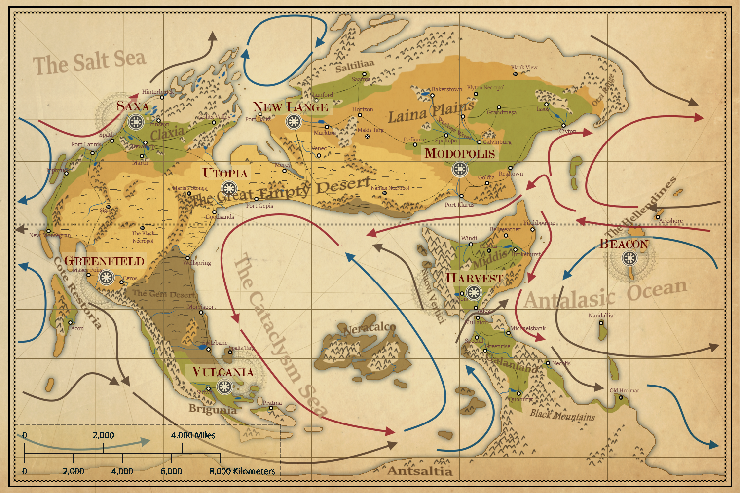
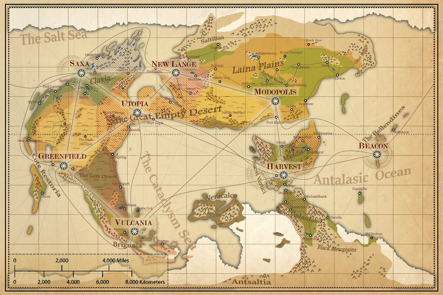
The planet Alver is the main planet of the setting. It is earthlike but about ⅔ the size of earth. The climate of Alver used to be varied and stable, but after The Cataclysm the world has become more hostile. There are many deserts, savannahs, and wastelands, and few forests remaining.
Geographic map (with ocean currents)

Geographic map (with sea ice extents)

Regions
The Cataclysm Sea
The very deep did rot: Oh Christ! That ever this should be! Yea, slimy things did crawl with legs Upon the slimy sea.
- Formerly the Galan Sea, expanded by the Cataclysm
- A fairly peaceful sea, often prone to Doldrums and hosting seaweed and pumice mats
- Huge swaths of the south of the sea freeze in winter, inhibiting sea traffic to the south of Neracalco
- When the sea freezes, the only western route through to the Antalasic Ocean is through the maze of Brigunia, near Vulcania
- Dark and greenish water, often shallow and very clear
- Closer to Neracalco in summer when the sea is thawed the water becomes lighter and more opaque, becoming milky white near the shore, due to tiny suspended ash particles
- Often foggy or misty overnight and in the early morning
- The current moves slowly in an anti-clockwise spiral
- Sections of the coastline consist of seafloor raised during the cataclysm, with strange thick muds and weird rock formations
- Sailors dislike crossing the open Cataclysm Sea and instead stay near the coastlines where possible
- There are many undersea rivers below the Cataclysm sea. These generally flow towards Neracalco, and carry enormous amounts of salty water, but flow slowly.
- There are many, many legends and tales of sightings of strange creatures here, more than in any other ocean or sea.
The Antalasic Ocean
- The largest and deepest ocean, also the most violent
- Dark, deep, cold water - deep blue
- Frequent large storms, high waves, icebergs, and strong winds
- The current moves counterclockwise in the southern hemisphere and clockwise in the northern
The Salt Sea
- The northern sea, very calm and generally shallow, crystal clear bright blue water
- The frigid water is often packed with icebergs from the North Pole
Antsaltia
- The South Pole landmass
- Poorly explored, appears to be an endless frozen desert
- Incredibly cold, windy, and exposed
- A landscape of glaciers, mountains, ice flats, and flowing salt rivers
Neracalco
- Mysterious large volcanic island formed at the centre of the Cataclysm impact
- Very few have landed or returned to talk about the island
- Sailors and pilots avoid the area
- Often surrounded by violent volcanic storms, or dense greenish fog
- Appears mountainous inland
Galanland
- A peninsula extending off Antsaltia
- Pleasantly temperate in the north, growing colder and more desolate towards the South
- Half of Galanland was destroyed in the Cataclysm, especially the west of the landmass
- In the north, fertile valleys are nestled between steep mountains, with fjords, glaciers, and swift meltwater rivers
- Rain and warmer winds blow in from the North
- Harsh weather occasionally rolls in from the South, bringing long blizzards, or dry cold snaps
- In general it is very wet and snowy
- There is also much volcanic activity, such as smoking fumaroles and geysers
- The Black Mountains is a large mountain range that extends South into Antsaltia
- Galanland is under the influence of Harvest
Middis
- A grassy, warm, and temperate continent that becomes very hot and dry away from the coast
- The western coast is rimmed by the Nuovi Vertici mountain range
- Much of the land is sparsely forested with tall trees and scrubby bush
- The sand and rocks are a mix of reddish sandstone and pale greenish basalt
- Middis is under the influence of Harvest
- Harvest is located in the Centre-South of Middis
The Hellendines
- An island chain in the Antalasic ocean
- Used to be an entire continent, now only eroded mountains and hills poke above the water
- Tall cliffs battered by waves, and steep rocky pillars make it dangerous to navigate for unfamiliar sailors
- It doesn't snow, but is very cold and foggy due to the cold currents of the Antalasic ocean
- The Hellendines are under the influence of Beacon
- Beacon is located on The Hellendines
Lania Plains
- A vast, semi-arid steppe
- Mostly limestone
- Dotted with hills, pockets of forests, and caves
- Green and relatively forested in the east, becoming more desert-like in the west
- The plains are home to vast numbers of nomad clans, who resist encroachment by settlers, prospectors, and explorers
- The Lania Plains are under the tenuous control of Modopolis in the East and New Lange in the West
- Modopolis is located in the South-East of The Lania Plains
- New Lange is located in the West of the Lania Plains
Saltiliaa
- Northern frozen wastes
The Great Empty Desert
- A massive desert formed and expanded by the Cataclysm
- Full of ancient ruins, and the ruins of pre-cataclysm nations
- Rocky, hot, and often mountainous
- The Spiny Mountains are a major chain of highly eroded mountains going North/South along the East coastal interior
- There are patches of savannah as well, and the occasional oasis
- The Great Empty Desert is under the influence of Utopia
- Utopia is located in the centre of the Great Empty Desert
Claxia
- Temperate and cold. Rocky and deeply green, with dense and dark pine forests
- Home to the largest forests still on Alver
- North Claxia is new land formed post-cataclysm from mountains that rose from the Salt Sea
- Many lakes, many old towns nestled between eroded valleys
- Claxia is under the influence of Saxa
- Saxa is located in the North-West of Claxia
Cote Restoria
- A hot and harsh mediterranean coastal region
- On the coastline the rocky desert meets the churning, cold Antalasic Ocean
- There is little fresh water or vegetation
- What plants there are are stunted and gnarled
- Greenfield is located on the Cote Restoria
The Gem Desert
- A large desert formed by the Cataclysm
- The terrain consists of black sand and pumice mixed with chunks of glassy quartz, and occasionally precious gems
- There are large boulders scattered about, cracked ground, and deep-fissure caves
- Very volcanically active. There are pools of acidic green liquids girt by yellow sulphurous rocks, bubbling orange mud pools, and red rock geysers
- The Gem Desert is under the influence of Utopia in the North and Vulcania in the South
Brigunia
- Harsh wet and windy coastline battered by the ocean waves
- There is a dividing mountain range that captures the rain coming from the West and stops it reaching the East coast
- It is cold and damp in the South
- The soil is black, and the grass and trees are in shades of orange and yellow
- There are many volcanic caves and features, especially towards the Gem Desert
- Brigunia is under the influence of Vulcania
- Vulcania is located in the centre-East of Brigunia
Notable Mountains
- Monte Secunda - Middis (Nuovi Vertici), 8,530m
- Huskar's Pike - Galanland (Black Mountains), 7,630m
- Hintertusk - Galanland (Black Mountains), 6,800m
- Noton - Galanland (Black Mountains), 6,100m (deep into Antsaltia)
- Kadiphonek - Galanland (Black Mountains), 5,200m (deep into Antsaltia)
- Achoravomas - Galanland (Black Mountains), 5,100m (volcano)
- Alkaron - Great Empty Desert (Spiny Moutains), 4,500m
- Yarak - Galanland (Black Mountains), 3,900m (Southernmost named mountain)
- Yikilth - Neracalco, height unknown